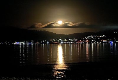
July 7, 2023
Clouds in the form of waves have been spotted in Queensland's Whitsundays region last night.
The clouds formed an incredibly rare surfing shape, with the bright moon lighting them up as they hovered over Airlie Beach.
The incredible image was captured by Nicole Temple.
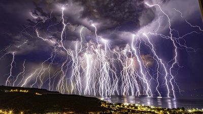
July 6, 2023
A photographer created this electrifying timelapse image as an electrical storm illuminated the skies above his hometown of Mudanya in Turkey.
Uğur İkizler captured 100 individual lightning bolts during a 50-minute period as the storm bore down on June 16, around midnight.
He then stitched those photos together to create one incredible photo that showed the ferocity of the weather event.

June 9, 2023
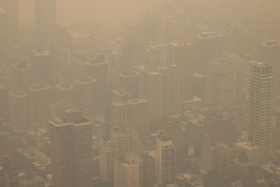
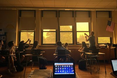
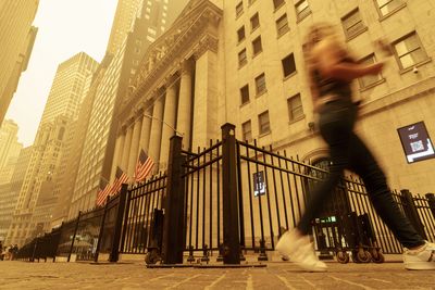
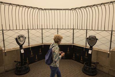
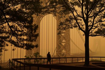
Bushfires in Canada caused a wave of orange to sweep over the US, with New York copping the brunt of the smoke.
Images have been released of New York skyline before and after the smoke.
New York's skyline stands tall in this photo before the fires.
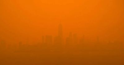
Days later, the conditions were much worse.
The iconic buildings are nearly impossible to see, as the orange smoke chokes the city of New York.
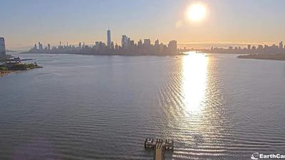
The sun reflects off the beautiful Hudson River with the New York skyline visible in the back.
This photo was taken before the wildfires poured smoke into the city.
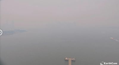
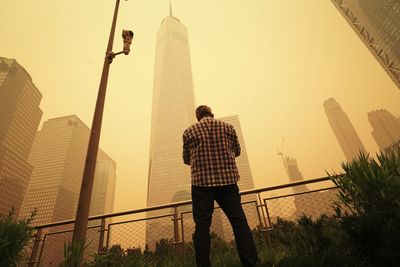
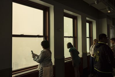
The same skyline is hidden behind a haze of smoke, which has made the air in New York "hazardous" to breathe in.
More than eight million people have been exposed to levels of pollution five times higher than the national air quality standard.
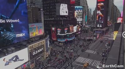
New York's busy time square photographed on a day with clear skies.
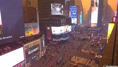
Now, the same intersection looks like something out of a dystopian sci-fi movie.
Residents have returned to wearing covid-era masks to protect their airways as the smoke continues to suffocate the city.
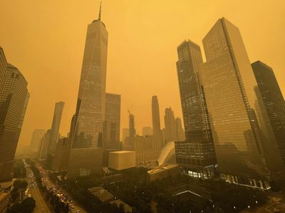
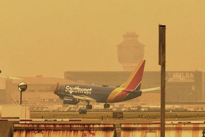
New York was steeped in an orange haze after smoke from Canada's wildfires poured into the US.
The smoke has grounded flights and prompted air quality concerns for more than 55 million residents in Pennsylvania, New York, New Jersey and Connecticut.
New York City; Jersey City, New Jersey; and New Haven, Connecticut all had "unhealthy" AQIs ranging from 155 to 171 on Wednesday morning.
"Yesterday, New Yorkers saw and smelled something that has never impacted us on this scale before," New York City Mayor Eric Adams said Wednesday.
"This is not the day to train for a marathon or to do an outside event with your children. Stay inside, close windows and doors, and use air purifiers if you have them."
The smoke covered iconic Skylines across the country.
New York City had the worst air pollution of any major city in the world at one point Tuesday night, before dropping to second-worst behind New Delhi, India, according to air quality tracker IQair.
At least 10 school districts in central New York state cancelled outdoor activities and events Tuesday.
New York City's mayor said the situation is expected to improve Wednesday, but will likely worsen Thursday.
May 3, 2023
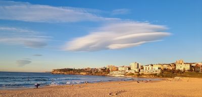
Beachgoers gracing Australia's most famous stretch of sand were treated to a rare, and strange, sight as a "saucer-shaped" cloud hovered above Bondi on Wednesday morning.
The images, shared by Weatherzone, show a solitary lenticular cloud.
"(It was) caused by mountain waves flowing off the Blue Mountains," the weather service says.
"Mountain waves, as the name suggests, are waves of rising and sinking air that are often caused when wind flows over a mountain range.
"Under certain conditions, small areas of cloud can form at the crests of each wave, on the leeward (downwind) side of the mountain range.
"This is what happened on Wednesday morning."

April 15, 2023
Northern light enthusiasts in Alaska got a surprise on Saturday when a light baby blue spiral resembling a galaxy appeared amid the aurora.
However the cause was a little more mundane than an alien invasion or portal.
The spiral formed from excess fuel released from a SpaceX rocket launched from California about three hours before.
"When they do that at high altitudes, that fuel turns into ice," space physicist Don Hampton, a research associate professor at the University of Alaska Fairbanks Geophysical Institute, said.
"If it happens to be in the sunlight, when you're in the darkness on the ground, you can see it as a sort of big cloud, and sometimes it's swirly."
It's not a common sight, with Hampton saying he's only seen it about three times.
- with Associated Press
January 8, 2023
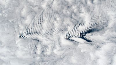
Strange arrow shaped-cloud formations were photographed above the Crozet Islands, which are located halfway between South Africa and Antarctica, in January.
The phenomenon are called wave clouds and it's not the first time they've formed, NASA explained.
"Wave cloud formations over these islands are a result of stable air masses over the South Indian Ocean flowing over and around the mountainous island terrain," it said.
"Wave clouds are produced when the warm air on the leeward side is pushed back upwards.
"The rising movement causes the moisture in the air to recondense and form more clouds, before it is forced back downward by gravity and evaporates again. The cycle repeats and forms a ripple pattern."
March 19, 2023
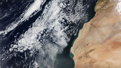
A distinct cloud formation has also been photographed above the Canary Islands.
They are called Von Kármán vortices.
NASA explained "they act like fingerprints for the movement of air."
"They can occur whenever an object interrupts airflow. In this case, they occurred as winds rushed past the tall volcanic peaks of the Canary Islands," the space agency said.
"Cloud vortices are often spotted downwind of isolated islands including near Guadalupe Island, near the coast of Chile, and in the Indian Ocean".