

New satellite images have shown the tragic reality of the devastating wildfires burning across Rhodes in Greece.
Topics:

The images, captured by Maxar Technologies, show just how vast the area currently being burnt across the European nation is.

The images were snapped on July 23 and 24, revealing where the most active fires are located along the southeastern coast of the island, near Gennadi.

The fresh pictures come hours after a firefighting plane crashed in the nation's south, killing all onboard.
Click through for more incredible satellite images from around the world.

As cold snaps swept NSW, a 50km band of snow fell on the state's Central Tablelands, just a couple hours west of Sydney, on the morning of Tuesday, June 20.
A NASA satellite overhead was able to spot the snowfall from space.
The red spot is used to differentiate the snowfall from the clouds, both of which would appear white in a normal satellite photo.

New satellite photos from Maxar Technologies have captured the reality of the devastating floods that wreaked havoc on northern Italy last week.
At least 14 people were killed, with heavy rain triggering hundreds of landslides, and 21 rivers burst their banks.
Here's how the region was affected.

This fields and farms in Faenza, on April 6.

The same fields and farms amid the flood crisis on May 23.

The Lamone River in Faenza on April 6.

The swollen Lamone River on May 23.
The Italian government has pledged a €2 billion ($3.26 billion) aid package to the affected areas.

Another part of the the Lamone River in Faenza on April 6.

The same part of the Lamone River on May 23.
The cost of road damage alone in Emilia-Romagna is estimated at €1 billion ($1.63 billion).
April 20
Weatherzone posted this image of the moon's shadow falling across Western Australia during the rare total eclipse on April 20.
The Western Australian town of Exmouth was the best place to watch the 62-second totality, with the moon blocking out the sun for a total of 62 seconds at 11.29am AWST.
April 13
One of the most destructive storms seen in more than a decade is bearing down on Western Australia's coast as a category 5 cyclone.
Cyclone Ilsa will have a "very destructive core" with extreme wind gusts up to 285km/h.
This is what the dangerous weather system looks like from space.
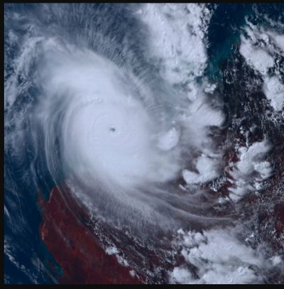
The destructive storm was initially expected to hit as a category 4 but was upgraded hours before making landfall.
It will mark the biggest cyclone since 2015, with those living in affected towns told it's too late to leave.
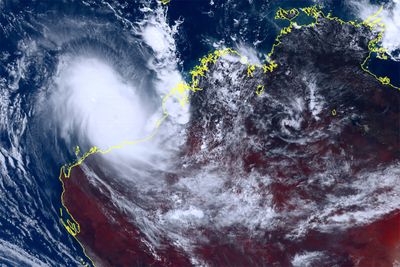
The cyclone will have a "very destructive core" with extreme wind gusts up to 285km/h and will impact towns around the major port hub of Port Hedland.
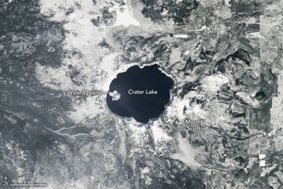
Deepest lake in America hardly ever freezes
Crater Lake in Oregon in the north west USA is regularly surrounded by deep snow and ice in the winter.
NASA's Operational Land Imager (OLI) on Landsat 8 took this image late last month.
Despite heavy snow - in 2021 12.5m fell, the lake rarely freezes.
That's because it is the deepest lake in the United States and among the deepest in the world.
It's an incredible 592 meters deep.
But it hasn't frozen since 1949, according to Crater Lake National Park.

Aside from the depth, the lake rarely freezes simply because it has a relatively small surface area.
In this NASA image, a small island known as Phantom Ship is visible just offshore.
The rocks of this island are remnants of an ancient volcanic cone that survived the eruption and collapse, NASA, said.
Thought to be 400,000 years old, it is the basin's oldest exposed rock.
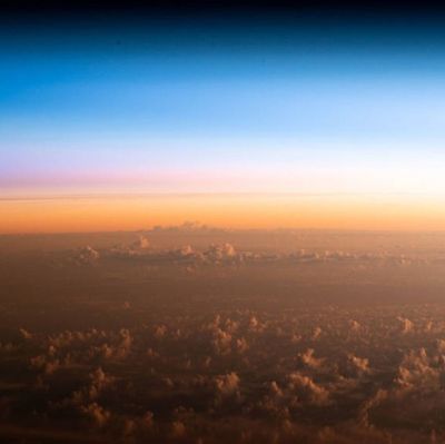
Sunrise captured from space
Astronauts on the international space station (ISS) have captured an orbital sunrise over New Zealand on camera.
The ISS orbits 418 kilometres (260 miles) above the earth at 23,000 km/h, meaning the astronauts on board see 16 sunrises and sunsets every day.
In this photo, clouds can be seen sitting above an orbital sunrise over the Pacific Ocean.
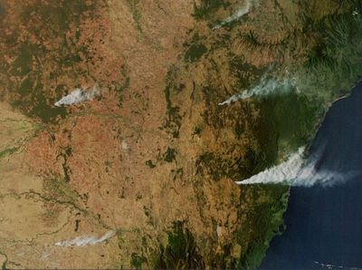
Smoke from NSW fires seen from space
The International Space Station captured impressive photos of massive smoke plumes stretching across the NSW landscape yesterday as dozens of fires burn across the state.
The smoke stretched over central and southern NSW in the evening and the Himawari-9 satellite was able to capture the image from about 36,000 km above the ground.

Fires have burnt through thousands of hectares of land with some not yet under control.
This photo of one of the five smoke plumes seen from space is from a grass fire burning in the area of Curraweela, north of Taralga in the Southern Tablelands.