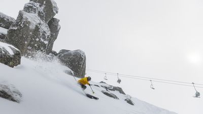
8-9 July, Thredbo, NSW snow
A snowstorm has delivered 48cm of fresh snow to Thredbo Resort this weekend, making it a bumper school holidays for skiers.
Down in the village, 15cm of the white stuff also fell.
Topics:

So far this winter, Thredbo has received 174cm of snow, a 14cm increase on last year.

Experts forecast another 10cm of fresh snow will fall over the next 24 hours before sunny skies return throughout the week.
There is more snow forecast for the coming weeks, a resort spokesman said.
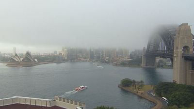
July 5 - Sydney fog
Thick fog settled over Sydney Harbour again on Tuesday night and into the early Wednesday morning. It was low enough to cover the top of the Sydney Harbour Bridge and smother many of the CBD's skyscrapers.

But it was even lower ahead of dawn, obscuring much more of the bridge.

Drivers were left facing potentially hazardous conditions on the CBD roads.

The Sydney Harbour Bridge was smothered by fog on the morning of Tuesday, July 4.
Elsewhere in the harbour city rain led the early-morning menu, but the fog also swept over towards the airport.
Crowds were out the doors, but airport officials said it wasn't the fog hampering flights, but rather the need to clear a backlog of cancelled and delayed bookings from recent days.
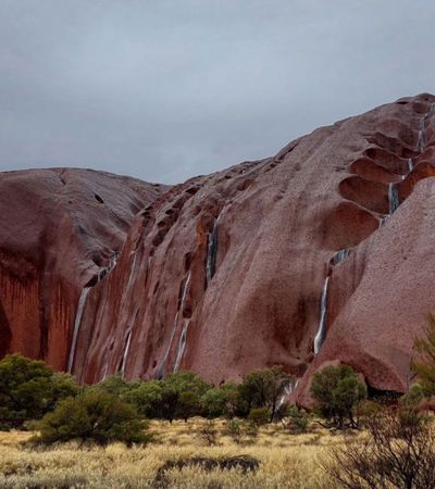
June 28 - Waterfalls on Uluru
Waterfalls appeared at Uluru after the region was hit with substantial rain over the past three days.
Tourists described the waterfalls as "magical" while exploring Uluru.

Parts of the Red Centre have received several months' rain in the last couple of days as a northwest cloudband continues to deliver "unseasonably heavy rain", Weatherzone said.
Uluru has received 64.6 mm of rain in the past 48 hours.
This is nearly four times its June monthly average, and its wettest pair of June days since 2004.

The magical falls can be seen all over Uluru and only appear a few times every year.
The rain is expected to continue through the remainder of the week.

June 25 - Mount Gambier SA
A huge sinkhole has opened on a busy South Australian street after the state was lashed with wild weather and heavy rain over the weekend.
The City of Mount Gambier it appeared a naturally occurring cave had given way.
It comes as Adelaide experiences its wettest year in four decades.

The newly formed hole in Mount Gambier appears to have swallowed a light post.
No other major damage was recorded.
With more rain on the way, the council has extended a large barrier in case the hole grows larger.
June 22
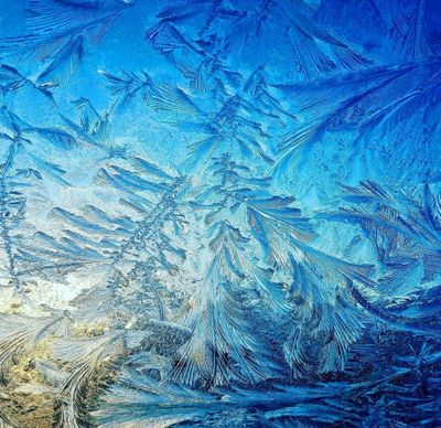
As temperatures plummet across the country's south, many people might be getting into cars and noticing frost patterns forming on windscreens like this one from Pakenham, Victoria.
A scientist at Washington State University has explained why water makes flower and fern shapes when it freezes on windscreens.

The frosty shapes start out as water in the air but when they land on a really cold surface like a windowpane, the water molecules freeze and join together to form ice crystal patters, Dr Wendy Sue Universe said.
This unique pattern formed on the sunroof on the outside of a car in Tasmania.

When temperatures dipped below freezing in parts of Victoria, the ice crystals were formed from hydrogen and oxygen.
"If the molecules run into something like a speck of dust, salt or even a bit of washer fluid from a car window, they may change their direction," Universe said.
This photo of a frost pattern with a stunning array of swirls and spirals was taken by a resident living in Stawell.
June 21 - Oberon
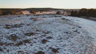
Oberon in the NSW Central West has received a light dusting of snow overnight, as a cold snap sees the thermostat plunge across much of Australia.

A 50km stretch of the NSW Central Tablelands was covered with snow this morning - an area so large that the snow could be seen clearly from space.


Snow is falling in Mount Hotham, in welcome news for would-be skiiers after the ski season was delayed due to a lack of snowfall at NSW's alpine resorts.

Snow blankets the ground in Oberon, where temperatures dropped to -7.5C overnight.

Oberon has a very high altitude of 1113 metres above sea level and will usually receive three or four dustings of snow each winter.