
Your web browser is no longer supported. To improve your experience update it here
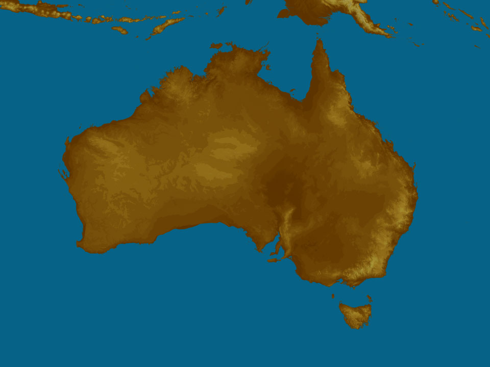
Australian weather forecast
National weather
Rain Radar map
18:25 AEST18:30 AEST18:35 AEST18:40 AEST18:45 AEST18:50 AEST18:55 AEST

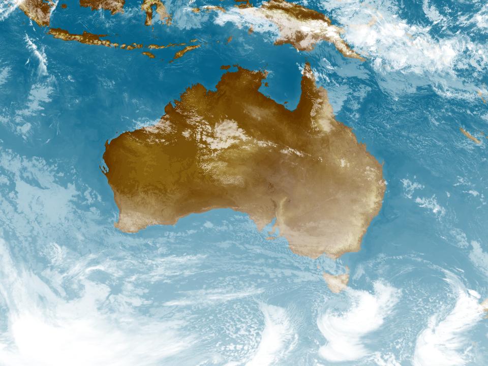
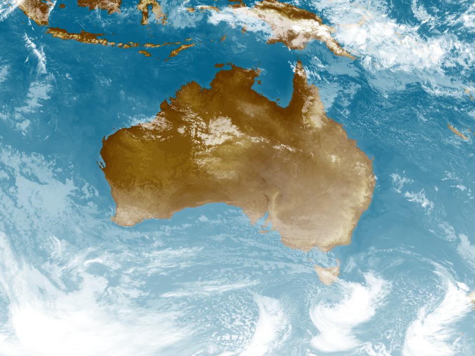
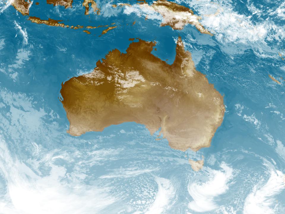
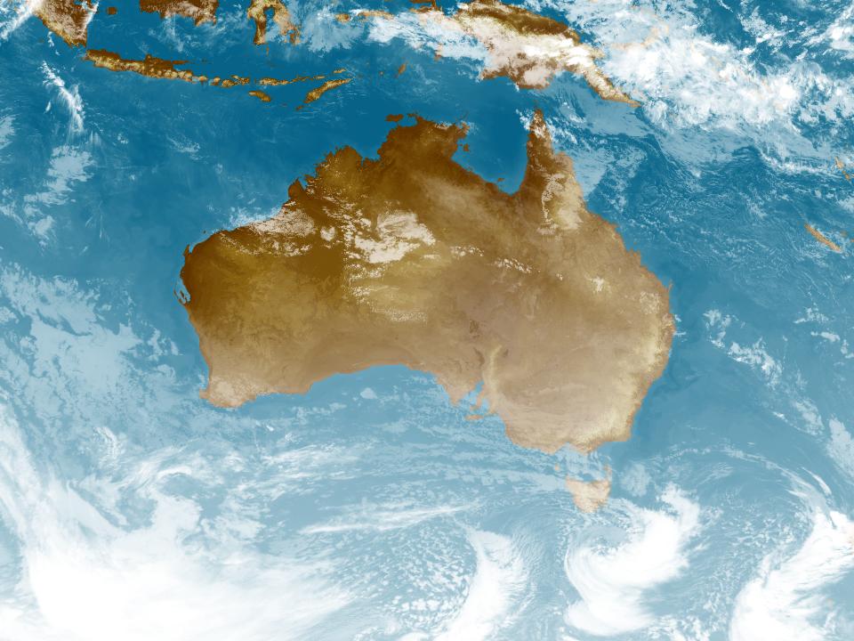
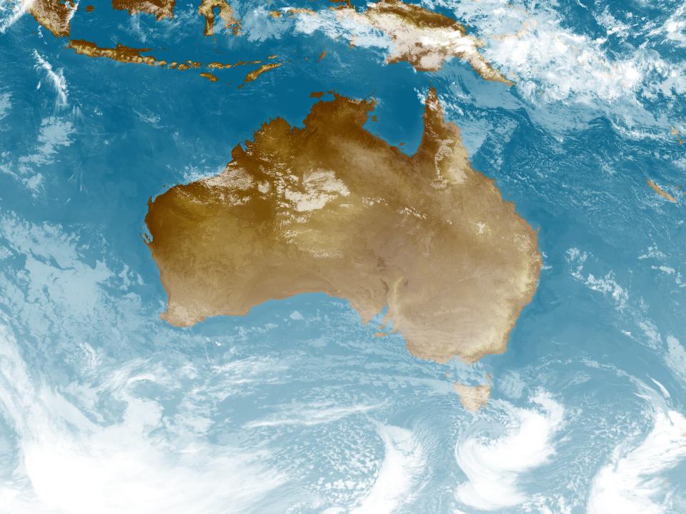
Weather Satellite
17:40 AEST17:50 AEST18:00 AEST18:10 AEST18:20 AEST18:30 AEST18:40 AEST


Synoptic weather chart
View national synoptic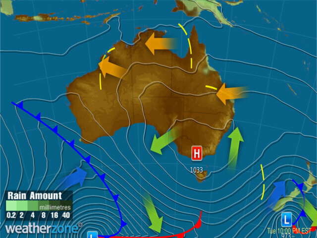
Wednesday 12:08 EST
Front is crossing WA, brining heavy rain, strong wind gusts and isolated thunderstorms to WA. High pressure to the east of the country is directing moist onshore winds along the northern NSW and Qld coasts, bringing a few showers. Dry elsewhere under high pressure.
Issued Monday 03:07 EST
Weather warnings
Strong Wind Warning for Tuesday for Perth, Bunbury Geographe and Leeuwin coasts
Australian Government Bureau of Meteorology Western Australia Marine Wind Warning Summary for Western Australia Issued at 04:00 PM WST on Monday 31 July 2023 for the period until midnight WST Tuesday 01 August 2023 Wind Warnings for Tuesday 01 August Strong Wind Warning for the following areas: Perth Coast, Bunbury Geographe Coast and Leeuwin Coast The next marine wind warning summary will be issued by 4:00 am WST Tuesday. ================================================================================ Check the latest Coastal Waters Forecast or Local Waters Forecast at http://www.bom.gov.au/wa/forecasts/map.shtml for information on wind, wave and weather conditions for these coastal zones. ================================================================================Minor To Moderate Flood Warning For The Murray River And Minor Flood Warning For The Edward River
Australian Government Bureau of Meteorology, New South Wales Minor To Moderate Flood Warning For The Murray River And Minor Flood Warning For The Edward River Issued at 05:40 PM EST on Monday 31 July 2023 Flood Warning Number: 24 Re-issue: Minor correction to Barham forecast text. MODERATE FLOODING CONTINUES ALONG THE MURRAY RIVER AT BARHAM MINOR FLOODING IS LIKELY ALONG THE MURRAY RIVER AT WAKOOL JUNCTION The main peak along the Murray River is approaching Barham where moderate flooding is occurring. Minor flooding is likely to develop at Wakool Junction during the weekend or from early next week. Minor flooding is continuing to ease slowly along the Edwards River. Murray River downstream of Tocumwal to Barham: Minor to moderate flooding is occurring along the Murray River downstream of Tocumwal to Barham. The Murray River at Torrumbarry Weir peaked at 7.48 metres around 07:00 am Friday 28 July and is currently at 7.43 metres and falling slowly with minor flooding (minor flood level 7.30 metres). The Murray River at Torrumbarry Weir is likely to remain above the minor flood level (7.30 m) for the next few days. The Murray River at Barham is currently at 5.96 metres and rising slowly, above the moderate flood level (5.80 metres). The Murray River at Barham may reach around 6.00 metres during Wednesday, with moderate flooding. Murray River downstream of Barham to Wentworth: Minor flooding is likely along the Murray River downstream of Barham to Wentworth. The Murray River at Wakool Junction is currently at 8.39 metres and rising. The Murray River at Wakool Junction is likely to exceed the minor flood level (8.80 m) during the weekend or early next week. The river level may reach around 9.30 metres around mid August, with minor flooding. Edward River: Minor flooding is occurring along the Edward River. The Edward River at Deniliquin is currently at 4.74 metres and falling slowly, with minor flooding. The Edward River at Deniliquin is likely to remain above the minor flood level (4.60 m) for the next few days. The Edward River at Stevens Weir Downstream is currently at 5.55 metres and falling slowly, with minor flooding. The Edward River at Stevens Weir Downstream is likely to remain above the minor flood level (5.50 metres) for the next few days. Flood Safety Advice: In life threatening emergencies, call 000 (triple zero) immediately. If you require rescue, assistance to evacuate or other emergency help, ring NSW and VIC SES on 132 500. * Avoid drowning. Stay out of rising water, seek refuge in the highest available place. * Prevent damage to your vehicle. Move it under cover, away from areas likely to flood. * Avoid being swept away. Stay out of fast-flowing creeks and storm drains. * Never drive, ride or walk through flood water. Flood water can be DECEPTIVE and dangerous.} For more emergency information, advice, and access to the latest river heights and rainfall observations and forecasts: * NSW SES: www.ses.nsw.gov.au * VIC SES: www.emergency.vic.gov.au * RMS Live Traffic: www.livetraffic.com * VicRoads: www.vicroads.vic.gov.au * Latest River Heights and Rainfall Observations: www.bom.gov.au/nsw/flood/southwest.shtml * Latest NSW Warnings: www.bom.gov.au/nsw/warnings/ * Rainfall Forecasts: www.bom.gov.au/australia/meteye/ * BOM NSW Twitter: www.twitter.com/BOM_NSW Next issue: The next warning will be issued by 02:00 pm EST on Wednesday 02 August 2023. Latest River Heights: Murray River at Albury,2.43,Falling,05:00 PM MON 31/07/23 Murray River at Corowa,4.00,Falling,05:00 PM MON 31/07/23 Murray River at Yarrowonga Downstream,3.66,Falling,05:00 PM MON 31/07/23 Murray River at Tocumwal,4.71,Falling,05:00 PM MON 31/07/23 Murray River at Echuca,91.87,Falling,05:00 PM MON 31/07/23 Murray River at Torrumbarry Weir,7.43,Falling,05:00 PM MON 31/07/23 Murray River at Barham,5.96,Rising,05:00 PM MON 31/07/23 Murray River at Swan Hill,3.91,Steady,05:00 PM MON 31/07/23 Murray River at Wakool Junction,8.39,Rising,05:00 PM MON 31/07/23 Murray River at Boundary Bend,6.78,Rising,05:00 PM MON 31/07/23 Murray River at Euston,47.53,Rising,05:00 PM MON 31/07/23 Murray River at Mildura Weir,33.34,Rising,09:00 AM MON 31/07/23 Murray River at Wentworth,30.25,Rising,05:00 PM MON 31/07/23 Edward River at Deniliquin,4.74,Falling,05:00 PM MON 31/07/23 Edward River at Stevens Weir Downstream,5.55,Falling,05:00 PM MON 31/07/23 Edward River at Moulamein,4.15,Rising,05:00 PM MON 31/07/23 This advice is also available by dialling 1300 659 210. Warning, rainfall and river information are available at www.bom.gov.au/nsw/flood. The latest weather forecast is available at www.bom.gov.au/nsw/forecasts.Severe Weather Warning (Destructive Winds) Furneaux Is, Western, U Derwent, South East, NE, E Coast, NW Coast, CN, C Plateau & Midlands
Australian Government Bureau of Meteorology TOP PRIORITY FOR IMMEDIATE BROADCAST Severe Weather Warning for Destructive Winds for Furneaux Islands, Western, Upper Derwent Valley, South East, North East, East Coast, North West Coast, Central North, Central Plateau and Midlands Forecast Districts. Issued at 5:16 pm Monday, 31 July 2023. DAMAGING TO LOCALLY DESTRUCTIVE WINDS THIS EVENING, EASING TUESDAY MORNING. Weather Situation A strong cold front is crossing the state during the afternoon and evening, resulting in damaging to locally destructive winds. Winds are forecast to ease during Tuesday morning. DESTRUCTIVE WINDS for the following areas: Furneaux Islands, Western, Upper Derwent Valley, South East, North East, East Coast, North West Coast, Central North, Central Plateau and Midlands Strong to DAMAGING WINDS of 55 to 65 km/h with peak gusts in excess of 100 km/h are likely across Tasmania and the Furneaux Islands, including over Hobart during Monday evening. Locally DESTRUCTIVE WIND GUSTS in excess of 125 km/h are possible over western and far southern Tasmania, and over exposed and elevated areas during Monday evening. Winds are expected to contract to parts of central and northern Tasmania overnight. DAMAGING WIND GUSTS with peak gusts of around 110 km/h are possible over parts of the Western Tiers and adjacent areas during Tuesday morning. Winds are expected to ease below warning thresholds by late Tuesday morning. A separate Severe Weather Warning for ABNORMALLY HIGH TIDES is current for parts of Upper Derwent Valley and South East Forecast Districts. For more information on warnings please check: http://www.bom.gov.au/tas/warnings/. Locations which may be affected include Devonport, Burnie, Launceston, St Helens, Swansea, Strahan, New Norfolk and Hobart. Maximum wind gusts recorded up to 5pm Monday: 200 km/h at Maatsuyker Island at 4:16pm 169 km/h at Scotts Peak at 4.25pm 146 km/h at Low Rocky Point at 2:33am 143 km/h at Strahan Airport at 3:10am 141 km/h at Mount Read at 4:05pm 139 km/h at Cape Bruny at 6:21am 135 km/h at Cape Sorell at 2:44am 128 km/h at Hartz Mountains at 4:30am 122 km/h at Kunanyi/Mt Wellington at 2:20am 122 km/h at Tasman Island Airport at 5:17am The State Emergency Service advises that people should: * Supervise children closely. * Check that family and neighbours are aware of warnings. * Manage pets and livestock. * Secure outdoor items including furniture and play equipment. * Be prepared in case of power outages and report any outages to TasNetworks on 132 004. * Beware of damaged trees and power lines and take care when driving. * Listen to the ABC radio or check www.ses.tas.gov.au for further advice. * For emergency assistance contact the SES on 132500. The next Severe Weather Warning will be issued by 11:00 pm AEST Monday. Warnings are also available through TV and Radio broadcasts, the Bureau's website at www.bom.gov.au or call 1300 659 210. The Bureau and State Emergency Service would appreciate warnings being broadcast regularly.Severe Weather Warning (Abnormally High Tides) for parts of Upper Derwent Valley and South East
Australian Government Bureau of Meteorology TOP PRIORITY FOR IMMEDIATE BROADCAST Severe Weather Warning for Abnormally High Tides for parts of Upper Derwent Valley and South East Forecast Districts. Issued at 4:59 pm Monday, 31 July 2023. Abnormally High Tides affecting parts of the southeast coasts this afternoon and evening ABNORMALLY HIGH TIDES for the following areas: Upper Derwent Valley and South East A vigorous cold front crossing Tasmania is bringing gale to storm force northwest to westerly winds to the warning area leading to elevated seas. This combined with spring tides is expected to cause a rising of sea levels significantly above the highest astronomical tides, which may lead to inundation of saltwater over low-lying coasts of the warning area, particularly west-facing coasts, around the time of peak high tides. Risk of inundation remains highest until 7 pm about eastern shores of Huon River, River Derwent and Great Bay. Sea levels are then expected to gradually abate during the evening. Locations which may be affected include New Norfolk, Huonville, South Arm, Lauderdale, and The Neck on Bruny Island. Severe weather is no longer occurring in the Western district and the warning for this district is CANCELLED. However, a separate Severe Weather Warning for Damaging to Locally Destructive Winds is current for most of Tasmania, including the Western district. Please check: http://www.bom.gov.au/tas/warnings/. Cancellation for the following areas: Western The State Emergency Service advises that people should: * Supervise children closely. * Check that family and neighbours are aware of warnings. * Manage pets and livestock. * Do not walk, ride or drive through flood waters. * Be prepared in case of power outages and report any outages to TasNetworks on 132 004. * Listen to the ABC radio or check www.ses.tas.gov.au for further advice. * For emergency assistance contact the SES on 132500. The next Severe Weather Warning will be issued by 11:00 pm AEST Monday. Warnings are also available through TV and Radio broadcasts, the Bureau's website at www.bom.gov.au or call 1300 659 210. The Bureau and State Emergency Service would appreciate warnings being broadcast regularly.Gale Warning for West, Central, Central Gippsland and East Gippsland coasts
Australian Government Bureau of Meteorology Victoria Marine Wind Warning Summary for Victoria Issued at 04:40 PM EST on Monday 31 July 2023 for the period until midnight EST Tuesday 01 August 2023 Wind Warnings for Monday 31 July Gale Warning for the following areas: West Coast, Central Coast, Central Gippsland Coast and East Gippsland Coast Wind Warnings for Tuesday 01 August Gale Warning for the following areas: Central Gippsland Coast and East Gippsland Coast Strong Wind Warning for the following areas: West Coast and Central Coast The next marine wind warning summary will be issued by 5:10 am EST Tuesday. ================================================================================ Check the latest Coastal Waters Forecast or Local Waters Forecast at http://www.bom.gov.au/vic/forecasts/map.shtml for information on wind, wave and weather conditions for these coastal zones. ================================================================================Sheep Graziers Warning for Midlands, Upper Derwent Valley and South East. Cancellation of Sheep Graziers Warning for East Coast
Australian Government Bureau of Meteorology Tasmania Warning to Sheep Graziers for Midlands, Upper Derwent Valley and South East forecast districts Issued at 04:37 PM EST on Monday 31 July 2023 Warning to Sheep Graziers for the following areas: Midlands, Upper Derwent Valley and South East forecast districts Sheep graziers are warned that cold temperatures, showers and strong westerly winds are expected during Monday and Tuesday. Conditions are expected to ease during the day on Tuesday. Areas likely to be affected include parts of the Midlands, Upper Derwent Valley and South East forecast districts. There is a risk of losses of lambs and sheep exposed to these conditions. Cancellation of Warning to Sheep Graziers for the following areas: East Coast forecast district The Warning to Sheep Graziers for the East Coast forecast district has been cancelled. The next warning will be issued by 11:00 pm EST Monday.Sheep Graziers Warning for Southern Tablelands and Snowy Mountains
Australian Government Bureau of Meteorology New South Wales Warning to Sheep Graziers for Southern Tablelands and Snowy Mountains forecast districts Issued at 04:37 PM EST on Monday 31 July 2023 Warning to Sheep Graziers for the following areas: Southern Tablelands and Snowy Mountains forecast districts Sheep graziers are warned that cold temperatures and westerly winds are expected during Tuesday and are expected to ease by the late morning. Areas likely to be affected include parts of the Southern Tablelands and Snowy Mountains forecast districts. There is a risk of losses of lambs and sheep exposed to these conditions. The next warning will be issued by 11:00 pm EST Monday.Fire Weather Warning for Darwin and Adelaide River, Gregory South East and Barkly North
Australian Government Bureau of Meteorology Northern Territory Fire Weather Warning for Darwin and Adelaide River, Gregory South East and Barkly North fire weather districts Issued at 04:06 PM CST on Monday 31 July 2023 Weather Situation Dry conditions with fresh and gusty east to southeasterly winds on Monday, increasing on Tuesday. For the rest of Monday 31 July: Extreme Fire Danger for the following areas: Barkly North For Tuesday 01 August: Extreme Fire Danger for the following areas: Darwin and Adelaide River, Gregory South East and Barkly North Bushfires NT and NT Fire and Rescue Service advise you to: Action your Bushfire Survival Plan now. Monitor the fire and weather situation through your local radio station, www.securent.nt.gov.au, and www.bom.gov.au. Call 000 (Triple Zero) in an emergency. For information on preparing for bushfires go to www.securent.nt.gov.au. The next warning will be issued by 5:00 am CST Tuesday.Strong Wind Warning for Lower South East Coast
Australian Government Bureau of Meteorology South Australia Marine Wind Warning Summary for South Australia Issued at 03:50 PM CST on Monday 31 July 2023 for the period until midnight CST Monday 31 July 2023 Wind Warnings for Monday 31 July Strong Wind Warning for the following areas: Lower South East Coast The next marine wind warning summary will be issued by 5:10 am CST Tuesday. ================================================================================ Check the latest Coastal Waters Forecast or Local Waters Forecast at http://www.bom.gov.au/sa/forecasts/map.shtml for information on wind, wave and weather conditions for these coastal zones. ================================================================================Storm Force Wind Warning for South East, South West & Central West coasts
Australian Government Bureau of Meteorology Tasmania Marine Wind Warning Summary for Tasmania Issued at 04:05 PM EST on Monday 31 July 2023 for the period until midnight EST Tuesday 01 August 2023 Wind Warnings for Monday 31 July Storm Force Wind Warning for the following areas: South East Coast, South West Coast and Central West Coast Gale Warning for the following areas: Derwent Estuary, Frederick Henry Bay and Norfolk Bay, Storm Bay, Channel, South West Lakes, Far North West Coast, Central North Coast, Banks Strait and Franklin Sound, East of Flinders Island, Upper East Coast and Lower East Coast Strong Wind Warning for the following areas: Central Plateau Lakes Wind Warnings for Tuesday 01 August Gale Warning for the following areas: Channel, Central Plateau Lakes, Central North Coast, Banks Strait and Franklin Sound, East of Flinders Island, Lower East Coast, South East Coast, South West Coast and Central West Coast Strong Wind Warning for the following areas: Derwent Estuary, Frederick Henry Bay and Norfolk Bay, Storm Bay, Far North West Coast and Upper East Coast The next marine wind warning summary will be issued by 5:00 am EST Tuesday. ================================================================================ Check the latest Coastal Waters Forecast or Local Waters Forecast at http://www.bom.gov.au/tas/forecasts/map.shtml for information on wind, wave and weather conditions for these coastal zones. ================================================================================Strong Wind Warning for Tuesday for Eden Coast
Australian Government Bureau of Meteorology New South Wales Marine Wind Warning Summary for New South Wales Issued at 04:05 PM EST on Monday 31 July 2023 for the period until midnight EST Tuesday 01 August 2023 Wind Warnings for Tuesday 01 August Strong Wind Warning for the following areas: Eden Coast The next marine wind warning summary will be issued by 4:10 am EST Tuesday. ================================================================================ Check the latest Coastal Waters Forecast or Local Waters Forecast at http://www.bom.gov.au/nsw/forecasts/map.shtml for information on wind, wave and weather conditions for these coastal zones. ================================================================================Strong Wind Warning for Tuesday for Peninsula and Cooktown coasts
Australian Government Bureau of Meteorology Queensland Marine Wind Warning Summary for Queensland Issued at 03:50 PM EST on Monday 31 July 2023 for the period until midnight EST Tuesday 01 August 2023 Wind Warnings for Tuesday 01 August Strong Wind Warning for the following areas: Peninsula Coast and Cooktown Coast The next marine wind warning summary will be issued by 4:45 am EST Tuesday. ================================================================================ Check the latest Coastal Waters Forecast or Local Waters Forecast at http://www.bom.gov.au/qld/forecasts/map.shtml for information on wind, wave and weather conditions for these coastal zones. ================================================================================Minor Flood Warning For The North Esk River
Australian Government Bureau of Meteorology, Tasmania Minor Flood Warning For The North Esk River Issued at 10:50 AM EST on Monday 31 July 2023 by Bureau of Meteorology, Hobart. Flood Warning Number: 5 RENEWED MINOR FLOODING OCCURRING AT CORRA LINN Renewed river level rises are occurring along the North Esk River at Corra Linn, where minor flooding is occurring and river levels are nearing a peak. In the 24 hours to 9:00 am Monday, rainfall totals of up to 12 mm were recorded across the North Esk catchment. Further rainfall totals of around 5-10 mm are forecast for the remainder of Monday and into Tuesday. This rainfall may cause renewed river rises and prolonged minor flooding at Corra Linn. This situation is being closely monitored, and warnings will be updated as necessary. Lower North Esk River around Corra Linn: Minor flooding is occurring along the Lower North Esk River at Corra Linn. The North Esk River at Corra Linn is currently at 2.83 metres and steady. The North Esk River at Corra Linn is likely to peak near 2.90 metres during Monday afternoon, with minor flooding. Renewed rises are possible with forecast rainfall, and river levels are likely to remain above the minor flood level (2.70 metres) for the remainder of Monday. Flood Safety Advice: SES Flood Warnings can be found at www.TasALERT.com Flood and storm safety advice is available at www.ses.tas.gov.au Road closure information is available at www.police.tas.gov.au} For emergency assistance call the SES on telephone number 132 500. For life threatening situations, call 000 immediately. Next issue: The next warning will be issued by 11:00 am EST on Tuesday 01 August 2023. Latest River Heights: St Patricks River at Nunamara Offtake,1.15,Steady,09:57 AM MON 31/07/23 North Esk River at Ballroom,1.47,Steady,08:00 AM MON 31/07/23 North Esk River at Corra Linn,2.83,Steady,10:16 AM MON 31/07/23 This advice is also available by dialling 1300 659 210. Warning, rainfall and river information are available at www.bom.gov.au/tas/flood. The latest weather forecast is available at www.bom.gov.au/tas/forecasts.
Weather Articles

Data supplied byWeather Zone
News Just In

Sam Kerr benched for Matildas crunch World Cup group clash

England coach's grim update on injured stars

Moment resident confronts machete-wielding men outside Melbourne home

New Sydney hotel nears opening after years of delays

Morrison slams robodebt royal commission findings as 'absurd'
:contrast(11)/https%3A%2F%2Fprod.static9.net.au%2Ffs%2F5613b47c-5706-4e87-91ff-43643739de8a)
Jail for murdering neighbours over garden hose dispute in Melbourne

Mother's anguish as items belonging to slain Melbourne woman stolen

Remains found in Tasmania confirmed to belong to missing teen

Brisbane's iconic Myer Centre closes doors for last time